VC17
| 2019-03-07 18:30:20
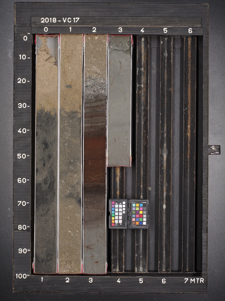
A very special and unexpected contribution to 'Climate as Artifact' was VC17. A sample of the soil underneath the North Sea.
With special thanks to Tanya Lippmann (VU), dr. Freek Busschers, Pieter van der Klugt and Sieb de Vries (TNO, Deltares).
EN: Tanya Lippmann (promovenda VU Amsterdam):
Peat growth and development is highly dependent on climate. Therefore, peat deposits (“basisveen”) submerged beneath the North Sea are a proxy for climatic change. Recently, during a marine cruise on the North Sea, a team of scientists (from Royal NIOZ Sea Research, TNO, Deltares, Utrecht University and VU University Amsterdam) drilled several sediment cores containing peat deposits. This is one of the retrieved cores. This core (VC17) was retrieved in order to further understand the transition from the last glacial period into the Holocene (onset c. 11,700 cal yr BP).
Marine sands sit above the peat. The peat material is easily identified by its light brown colour. The changes in colour and ‘stripes’ signify changes in vegetation type and growth rate. This particular peat is composed of Sphagnum moss. It has been preserved beneath the sea floor in an oxygen free environment. Thereby, preventing decomposition.
This work will contribute to understanding the climate variability in the Early Holocene and the development and botanical succession of peat ecosystems in general.
Scientists aim to reconstruct past vegetation change over time, based on plant macrofossil analysis, in different areas of the North Sea including the Doggers Bank, a submerged island that was home to prehistoric humans. Not only does the project aim to understand how peat transitions from one peat type to another but whether there is methane being produced by microorganisms living in the peat.
NL: Toelichting dr. Freek Busschers
Senior Geologist, TNO - Geological Survey of the Netherlands
Zie https://www.nioz.nl/en/blog/north-sea-expedition-sea-level-rise
Boring komt van de Noordzee, ongeveer 70 km ten westen van IJmuiden.
Het is een doorgezaagde pvc buis van 10 cm doorsnee en 1 m lengte.
De boring is gezet op de bodem van de Noordzee. De waterdiepte is hier ongeveer 25 meter.
De verschillende sedimenten liggen OP elkaar omdat de zeespiegel geleidelijk is gestegen.
Zand uit de laatste ijstijd afgezet door de wind. De Noordzee lag toen nog droog omdat al het water was opgeslagen in grote ijskappen op Scandinavie en Noord-Amerika. Ongeveer 14.000 jaar oud.
12.000 jaar geleden smelten door klimaatverandering de de ijskappen grotendeels af. Hierdoor begint de Noordzee weer vol te lopen. Het eerste moment dat je kan zien dat de Noordzee weer vochtig wordt, ongeveer 9500 jaar geleden, is deze veenlaag. Het geeft aan dat de grondwaterspiegel stijgt en het gebied veranderd in een groot moeras. Dit oude moeras zie je uiteindelijk terug in een laag samengedrukte planten, ook wel veen genoemd.
9000 jaar geleden veranderd het moeras in een ondiepe zee / waddengebied waarin klei wordt afgezet. Je kan zien dat het een zee is door de gelaagdheid van de klei en ook door zogenaamde kiezelwieren, een algensoort, ook wel diatomeen genoemd, alleen zichtbaar met een microscoop).
Vanaf 8000 jaar geleden is de Noordzee veel dieper geworden. De zeebodem bestaat uit zand met schelpen.
Met dank aan Pieter van der Klugt en Sieb de Vries, TNO, Deltares.
